Fort Independence
Baby, Baby, Where Did Our Fort Go?
by Michael Laferrier

This post originated over at the former Rhode Island Monuments, Memorials and Markers page on Facebook.
Revolutionary War Fort Disappears
Aerial Maps Confirm Disappearance
Search Initiated
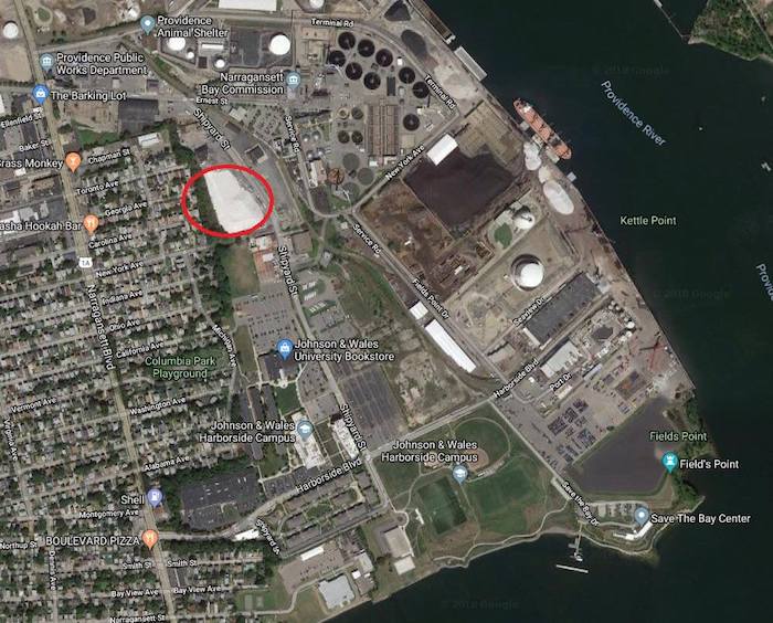
Crime Scene: Fort Independence, Field's Point, Providence
GPS: 41.792849, -71.392138
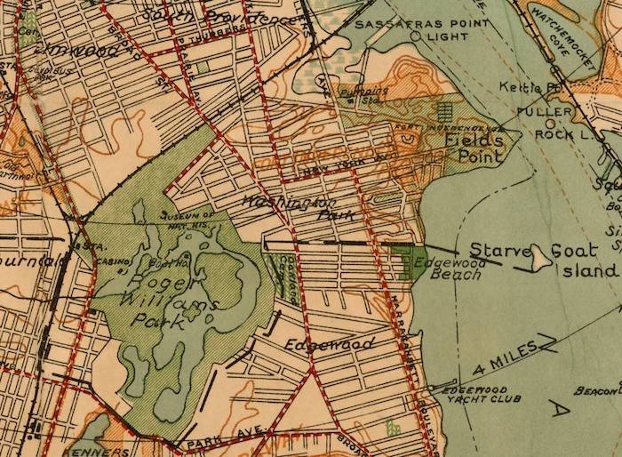
In late 1775, the town of Providence erected various earthworks, entrenchments, and fortifications to protect the city from British sea attacks. One of the forts, named Robin Hill Fort, was located on a bluff near Fields Point. Nearby were earthworks/entrenchments at Sassafras Point and Field's Point proper.
Here's a snippet from the 1914 Report of Committee on Marking Historical Sites in Rhode Island (Part 1):
The hill upon which this fort was erected was called, possibly at that time, but surely within a few years later, Robin Hill. A plat of the William Field property, now in the City Record Office, dated 1816, shows the outline of the fort and calls it "Robin Hill Fort." The name, Fort Independence, by which recent generations have known the work, was evidently fastened upon it by later map-makers, somewhere about the middle of the last century. A writer in the Providence Press of August 7, 1869, in referring to the fort as a relic of the War of 1812, says: It is located "on Robin Hill, and is now called Fort Independence. An old gentleman now living in the city, who helped to construct some of the works, says it was originally called Fort Robin Hill. When or why the name was changed, it is impossible to say."
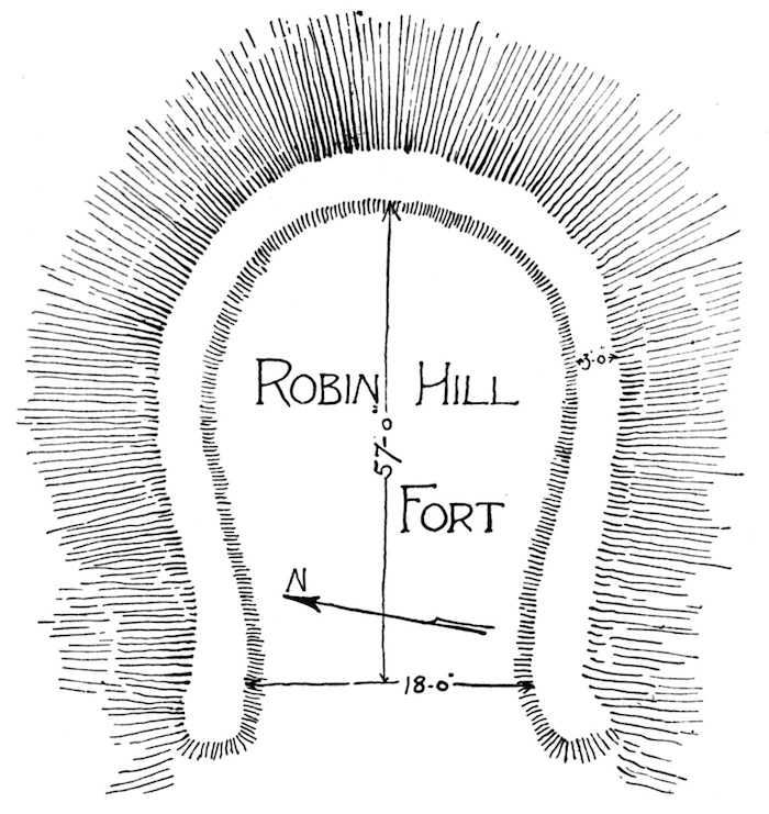

In 1907, an historical tablet was installed at the fort site, and at the earthworks at Field's Point proper. According to a 1912 National Geodetic Survey report... "A bronze tablet set in a cement base and bearing the inscription Fort Independence, erected on Robin Hill, 1775, strengthened 1814, is also within the old fort. It is held in position by 4 bolts and the lower one on the left as one faces the tablet is used as a reference mark."


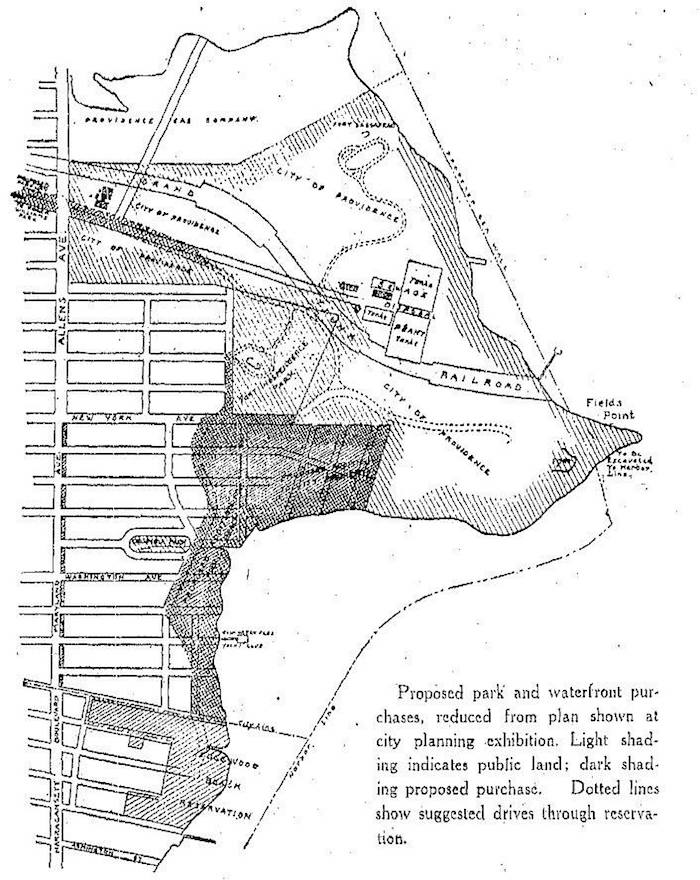
In the early 1900s, there were plans afoot to create a vast park system that would connect Fort Independence, Roger Williams Park, and the Edgewood Reservation. From what I can gather, the immediate fort and environs were in rough shape, but with much potential. Here's a snippet from a 1911 Providence Journal article expressing pleasure in the newly acquired fort property:
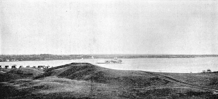
Coming into prominence in the long ago as the keystone of the defenses of the rebellious subjects of King George the Third, the historic spot has been threatened with obliteration on divers [various] occasions. The presence of unsightly shacks upon its lofty heights and steep hillsides, making it an eyesore, has been dreaded by the aesthetic; inroads of the modern steam shovel, which would speedily wipe out its queer, irregular hills and vales, has caused the lover of historic landmarks uneasiness of mind; and many advocates of breathing spots and play-grounds for city dwellers have become discouraged in the campaign started a number of years ago to have the property purchased by city or State. But in spite of its threatened destruction and inroads of the plat maker, the old hill has withstood the attacks of modernism and the war-time relic, its parapets and redoubts well preserved, henceforth will be a resort of pleasure, secure for all times against vandal hands. And it is fitting, perhaps, that it should be, for it is practically the only Revolutionary fortification within the city limits that has retained any well-defined semblance of its pristine appearance.
The purchase of upward of 68,900 square feet of land between New York and Fort avenues adds another Important link to the comprehensive system of parkways planned for the west shore. It brings under public control practically all of the remaining unimproved land in the indefinite territory designated as Field's Point and affords the city an ideal location for a magnificent marine park within three miles of the City Hall. The lofty crest of the old embankments, which were hurriedly thrown up in the troublous days of 1775, commands a fine view of the city and bay.

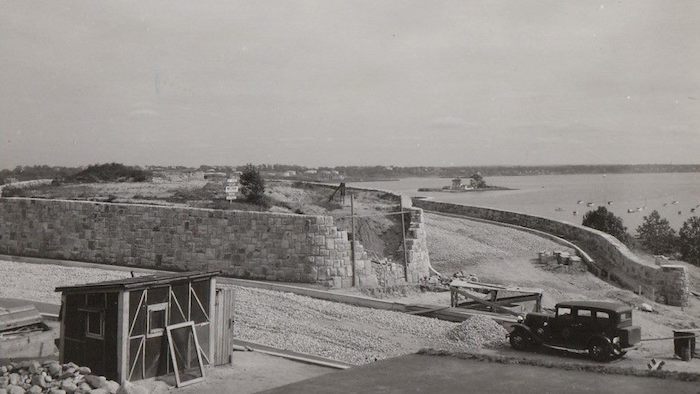
In 1937, the Works Progress Administration (WPA) initiated a restoration project that included building walls/steps, parking lots, and driveways on the fort site that allowed the public to save an historical Revolutionary War fort location and savor a grand view of Narragansett Bay. Here's a snippet from a March 7, 1937 Providence Journal article:
Now a road 30 feet wide and on a level with Georgia Avenue already circles the hill. From this stone steps will rise to the summit where the Revolutionary tablet commemorates the original building of a fort. To the north of the roadway a huge parking space is being leveled off while north of this a toboggan slide, graded for children, will be built from the remnants of the old slide for adults. The whole park project is 680 feet long by 300 feet wide and will include flower beds, walks, sidewalks 12 feet wide, a roadway on the west 36 feet wide. Visitors will enter from Georgia Avenue, circle the fort, park their cars at the parking lot and return for a view of the surrounding country from the summit. Immediately below them they will see all of the upper harbor and the Port of Providence with its shipping. Exits will be provided through Georgia and New York Avenues from Fort Avenue. When completed the new Fort Independence Park will be a show-spot and not an eyesore.
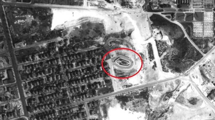
All was looking good until 1952... Aerial map investigations indicated the fort had disappeared; seemingly swept away, plowed under, or obliterated.


So, what happened to Fort Independence and the Revolutionary War tablet? The marker is still a mystery*, but the fate of the fort is known... DYNAMITE leveled the fort to rubble in 1942!!
Here's a snippet from a May 30, 1942 Providence Journal article:
E.J. McCall rushed in where the British feared to tread and at 5 o'clock yesterday morning set off a charge of dynamite that reduced Fort Independence—or most of it—to rubble. After half an hour of loading the explosive into the skillfully drilled holes, McCall surveyed the fort briefly, stepped back 100 feet to the plunger and then fired the heavy charge of dynamite without arousing persons asleep in houses 30 or 40 feet across the street from the famous fort, which has been condemned as part of the Rheem Manufacturing Company's new shipyard at Field's Point. Thousands of tons of rock and earth broke asunder and settled, with two-thirds of the cut-stone wall, which formed a turret 16 feet high and 100 feet across, knocked down at one shot. The other third of the wall, left standing, was to be demolished at 6 o'clock this morning, with McCall again loading and firing the dynamite.
Epilogue: The US Maritime Commission had determined that the Fields Point area was essential to the war (WWII) effort. According to newspaper reports, the fort area was to be used for fill and storage related to the new shipyard!
Who knows... if we look hard enough, we may find some cut-stone wall remnants at Save the Bay!!
*There are a couple of online references indicating remnants of the fort, and the monuments, are located at nearby Columbia Park. I know of a couple of search missions that did not yield any results. Let me know if you have better luck...

Michael Laferriere, an IT professional for over thirty years, curates multiple Facebook pages under the umbrella of www.lookseeri.org. Pages include Rhode Island Ruins, Hiking in Rhode Island, Rhode Island Historic Cemeteries, RhodeTrip, IntheDay, and LookSeeRI. Pages focus on Rhode Island area topics such as ruins, roads, rails, remnants, cemeteries, hiking, maps, monuments, memorials, history, and rhodescapes. In addition, Michael is webmaster of the Rhode Island Historic Cemeteries Database website.